
Current Projects
The LASERS lab engages in a variety of research projects aimed at supporting different sectors of natural resource management including agriculture, forestry, hydrology and land use/land cover mapping. Our current research projects in the field of agriculture and forestry are outlined below:
Unmanned aerial systems project for precision agriculture and high throughput field phenotyping, Funded by Texas A&M AgriLife Research, 2015 – 2017
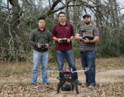
With the increased availability of small unmanned aerial systems (UAS) in recent years, their practical application in precision agriculture seems all the more possible. Under an interdisciplinary AgriLife research project, the LASERS lab is conducting applied research in the use of small UAS for precision agriculture and plant phenotyping. Using both self-engineered and commercial UAS, the LASERS lab has provided high spatial resolution imagery to enable plant breeders and agronomists at Texas A&M university assess in-field variability of their experiments, for sorghum, corn, wheat, and weed research. Our research efforts also extend to development of image analysis procedures for the derivation of phenotypic data such as plant height from captured imagery to enable scientists assess differences in growth and genetics among crop hybrids under study, the development of methods to support extraction of information from captured imagery including: detection and counting of sorghum panicles, characterization of panicle sizes and plant population estimation.
Ice, Cloud,and land Elevation Satellite (ICESat-2) Early Adopter Program

The ICESat-2 Early Adopter (EA) program promotes applications research to provide a fundamental understanding of how ICESat-2 data products can be scaled and integrated into organizations’ policy, business, and management activities to improve decision making efforts. The LASERS lab received research grants from NASA to conduct feasibility studies on the application of ICESat-2 data for vegetation applications.
For the rest of projects check the subheadings under Agriculture, Forestry, Hydrology and Land cover Land use