-
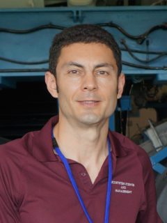
Sorin Popescu - Professor
- Office:
- 534 John Kimbrough Blvd., WFES 334, 2120 TAMU, College Station, TX 77843-2120
- Email:
- s-popescu@tamu.edu
- Phone:
- 979-862-2614
- https://lasers.tamu.edu/
- Undergraduate Education
- Forest Engineering, Transylvania University of Brasov, Romania
- Graduate Education
- PhD, Virginia Tech
- Courses Taught
- ESSM 446 / 689 Unmanned Aerial Systems (UAS) for Remote Sensing - Spring 2021, co-tought with Dr. Lonesome Malambo
- ESSM 655 Remote Sensing of the Environment - next offering Fall 2021
- ESSM 444 Remote Sensing of the Environment - next offering Fall 2021
- ESSM 656 Advanced Remote Sensing - next offering Spring 2022
- FRSC 389 Interpretation of Aerial Photographs (not offered anymore, packaged into ESSM 444/655)
Google Scholar Citations Webpage
Thomson Reuters ResearcherID: D-5981-2015: http://www.researcherid.com/rid/D-5981-2015
Brief Bio and Research Interests
Dr. Sorin Popescu is a Professor in the Department of Ecology and Conservation Biology (ECCB) at TAMU. He has been employed as TAMU faculty for almost 18 years, since June 2003. Dr. Sorin Popescu’s academic interests focus on combining ecological sciences and technology to support scientific discovery and conservation, and inform actions to better understand and manage our natural environment. Through combining elements of technoecology, ecoinformatics, and remote sensing with advanced Earth imaging technology, lidar and novel data analytics, Dr. Popescu’s research and teaching interests meet the need of next-generation scientists to address increasingly complex ecological research questions and challenges from local to global scales. He obtained his Ph.D. degree in Forestry at Virginia Tech. He currently serves on the National Aeronautics and Space Administration (NASA) Science Team for the ICESat-2 satellite mission, the Ice, Cloud, and land Elevation Satellite-2, launched in Sept 2018. Dr. Popescu teaches a senior-level undergraduate course in Remote Sensing of the Environment (ESSM 444) and two graduate courses, Remote Sensing of Environment (ESSM 655) and Advanced Remote Sensing (ESSM 656). Dr. Popescu also co-teaches a drone remote sensing class, ESSM 446/689. Throughout his tenure at TAMU, he has chaired to completion a total of 16 graduate students, including 7 doctoral students. Selected awards and honors received by Dr. Popescu include: Dean’s Outstanding Achievement Award for Interdisciplinary Research Team Excellence, College of Agriculture and Life Sciences (2018), ESSM Excellence Award in Discovery/Innovations (2017), American Society for Photogrammetry and Remote Sensing (ASPRS) Outstanding Workshop Instructor Award (2014), NASA New Investigator Award in Earth Sciences (2008), ESSM Graduate Professor of the Year (2008 and 2014), First Honorable Mention for 2005 ASPRS Talbert Abrams Award for Authorship and Recording of Current and Historical Engineering and Scientific Developments in Photogrammetry, and NASA Earth System Science Fellowship (1999).