
NASA ICESat-2 Science Team, Vegetation Science: Mapping Vegetation biophysical parameters – canopy height, canopy cover, above ground biomass

ICESat-2 Science Team

Dr. Popescu is one of the vegetation scientists on the ICESat-2 Science Team (ST). The ST for NASA’s ICESat-2 spaceborne mission is a group of competitively selected scientists with the core objective in advancing the science goals and providing guidance and advice to the ICESat-2 project to ensure the mission meets its science requirements. The PI’s LASERS group contributes algorithmic developments for processing ICESat-2 photon counting lidar (PCL) to derive top of canopy and ground elevation information. Such vegetation height information can be used for deriving other biophysical parameters, including percent canopy cover and biomass.
People
The project is supported by NASA. Key people working on this project include:
- Sorin Popescu (Professor/PI, Dept. Ecology & Conservation Biology)
- Lana Narine, Co-PI, Associate Professor, Auburn University
- Lonesome Malambo (Research Scientist/Co-PI, Dept. Ecology & Conservation Biology)
- Justinn Jones, PhD Student
- Hailey Schmidt, PhD Candidate
- Sarah Tasnim, PhD Student
Continental US Canopy Height Map from ICESat-2 and ancillary data at 30 m spatial resolution
Data download:
- Data set DOI: http://doi.org/10.5067/J8DMNXTBZ22J
Data set citation: Malambo, L. & Popescu, S. C. (2025). ICESat-2 Derived Canopy Height Model. (IS2CHM, Version 1). [Data Set]. Boulder, Colorado USA. NASA National Snow and Ice Data Center Distributed Active Archive Center. https://doi.org/10.5067/J8DMNXTBZ22J.
Data announcement: https://nsidc.org/data/user-resources/data-announcements/new-data-set-release-icesat-2-derived-canopy-height-model-version-1
US ICESat-2 Canopy Height Map
The LASERS lab has conducted various studies with NASA’s ICESat-2 spaceborne lidar data ranging from algorithm development for photon noise filtering and classification, validation of ICESat-2 data and production of gridded datasets describing various forest biophysical parameters such vegetation canopy height.
An initial version of a 2020 gridded canopy height map across the contiguous US has been developed. The gridded dataset was generated through a regression approach using ICESat-2 canopy heights and ancillary Landsat, LANDFIRE and topographic variables to produce a spatially explicit 30-m canopy height product across the contiguous United States.
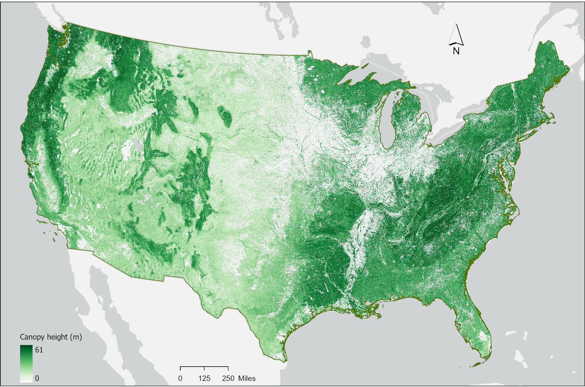
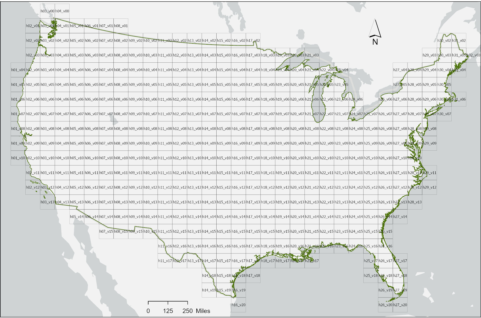
The gridded canopy height dataset is been distributed as tiled images according to the U.S. Landsat ARD Tile Grid System. Please see figure below. Each tile is saved and identified by the horizontal and vertical coordinates of the grid system e.g. cchm_083123_h02_v05.TIF for tile with horizontal coordinate 0f 02 and vertical coordinate of 05. The whole dataset can be downloaded using this link.
Project-related publications
- Lu, M.-K., S. Popescu, L. Malambo, A. Hudak, A. Lister, 2025. Mapping aboveground biomass in Oregon, Washington, Idaho and California with ICESat-2, GEDI and ancillary data. Forest Ecology and Management 595, 123040 https://doi.org/10.1016/j.foreco.2025.123040
- Lu, M.-K., S. Popescu and B. Campbell. 2025. Use of GLOBE Observer Citizen Science Data to Validate Continental-Scale Canopy Height Maps Derived from ICESat-2 and GEDI. Frontiers in Environmental Science. 13, https://doi.org/10.3389/fenvs.2025.1635707
- Lu, M.-K., S. Popescu and L. Malambo. 2025. Improving ICESat-2 Photon Classification and Tree Height Estimation Using Moran’s I and Machine Learning. Science of Remote Sensing. https://doi.org/10.1016/j.srs.2025.100251
- E. Akturk, S.C. Popescu, and L. Malambo. 2023. ICESat-2 for Canopy Cover Estimation at Large-Scale on a Cloud-Based Platform. Sensors 2023, 23, 3394. https://doi.org/10.3390/s23073394
- Narine, L.L., S.C. Popescu, and L. Malambo. 2023. A Methodological Framework for Mapping Canopy Cover Using ICESat-2 in the Southern US. Remote Sensing 15, 1548. https://doi.org/10.3390/rs15061548
- Malambo, L., S. Popescu, and M. Liu. 2023. Landsat-Scale Regional Forest Canopy Height Mapping Using ICESat-2 Along-Track Heights: Case Study of Eastern Texas. Remote Sensing 15(1), 1. https://doi.org/10.3390/rs15010001
- Liu, Meng, S.C. Popescu and L. Malambo. 2021. Effects of spatial resolution on burned forest classification with ICESat-2 photon counting Data. Frontiers in Remote Sensing 2:666251. https://doi.org/10.3389/frsen.2021.666251
- Malambo, , Popescu, S., 2020. PhotonLabeler: An Inter-Disciplinary Platform for Visual Interpretation and Labeling of ICESat-2 Geolocated Photon Data. Remote Sensing. 12 (19), 3168. https://doi.org/10.3390/rs12193168
- Narine, L.L., S.C. Popescu, and L. Malambo. 2020. Using ICESat-2 to Estimate and Map Forest Aboveground Biomass: A First Example. Remote Sensing12 (11), 1824. https://doi.org/10.3390/rs12111824
- Liu, S. Popescu, and L. Malambo. 2020. Feasibility of Burned Area Mapping Based on ICESat-2 Photon Counting Data. Remote Sensing 12(1), 24 https://doi.org/10.3390/rs12010024
- Popescu, S.C., T. Zhou, R. Nelson, A. Neuenschwander, R. Sheridan, L. Narine, and K.M. Walsh, 2018. Photon counting LiDAR: an adaptive ground and canopy height retrieval algorithm for ICESat-2 data. Remote Sensing of the Environment 208: 154-170. https://doi.org/10.1016/j.rse.2018.02.019